Florida Space IndustryStreet Economics® · The Florida space economy on a network and a lineage
Street Economics®

Florida Space Industry

A network and lineage map of the Florida space economy read as one statewide supply chain: the launch coast, the satellite and engine plants that feed it, the primes and universities behind them, and the statutory spaceport territory that runs from the Panhandle to Miami-Dade.

Work in progress. This map is not exhaustive. It presents the result of documented research at this release and changes as sources are added, corrected or superseded. Every node is based on at least one public source and carries its sources and confidence class. If something is missing or wrong, submit it.

Public disclosure policy: This map uses public business records, public corporate filings, federal and state statute, agency records, public property and lease records, public procurement records, public calendars, public civic documents, public press coverage and public listings. It maps commercial and public infrastructure and documented civic activity, not endorsements, partnerships or private behavior. Inclusion does not require participation, consent or approval. The map corrects factual errors promptly and considers removal requests case by case where a listing is outdated, an entity has closed, publication presents a material safety concern, or the entity is not conducting public facing activity. Public commercial and public sector infrastructure is mappable; private behavior is protected.
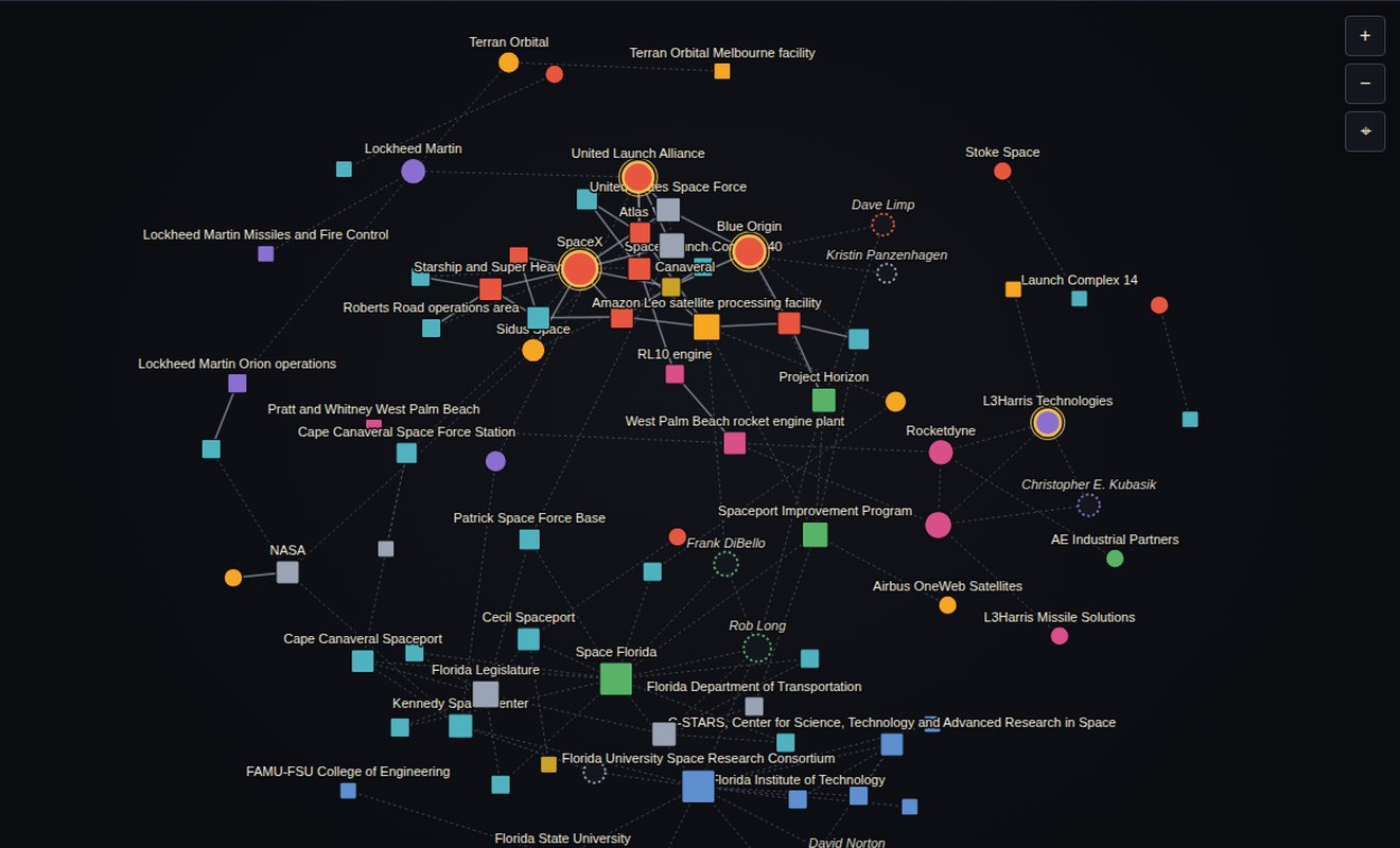
94 nodes: companies, facilities, launch complexes, vehicles, agencies, programs, institutions and people · 147 connections · 9 lanes · 10 hub regions · 8 counties of statutory spaceport territory
Version 1.8.0. Data current through 19 September 2026. As of the cutoff, projects and facilities are described only by their documented status: operating, announced, under construction, under repair, scheduled, inactive or otherwise pending. No activity is described as complete without a record of completion.
The network view of the interactive network mapNetwork view. Three more: Lineage timeline, the state at county scale, and 3D, plus a Play animation from 1949 to 2026.

Read the reference

The same text as the PDF, generated from the same data file as the map, so the counts never disagree.

OrientationHow to read this mapWhat the nodes and lines mean, the four things that are not the same, the inclusion rule, the people rule, the timeline placement rule, the lanes, the hub regions and how confidence is graded.The frameThe statutory spaceport systemThe eight counties of statutory spaceport territory, the subsection that names each one, the ten mapped places inside the system and why a designation is not a launch site.The coastThe launch coast and the Eastern RangeCape Canaveral, Kennedy and Patrick inside one statutory subsection, the pads and complexes, the operators and vehicles, and what a record of decision does and does not authorize.The argumentThe chain off the coastThe argument in one number, the regions that carry it, what South Florida actually is, and why ports and logistics is incomplete rather than minimal.CaseThe engine that changed hands twiceOne Palm Beach County plant, three successive operators inside four years, and the same engine on the pad throughout.The instrumentThe state's handSpace Florida, the Spaceport Improvement Program, and how a state appropriation becomes a private building on public spaceport ground.The pipelineThe state designates a research entityThe Florida University Space Research Consortium, its seven members, the Kennedy agreement, and why it ranks so high by betweenness on this graph.The cutoffAnnounced, and designated: two different thingsEverything announced, funded, approved, under construction or scheduled at the cutoff, kept apart from land the legislature has classified and nothing more.ComputedNetwork position and what it does not meanDegree, betweenness on the full graph, betweenness on the industrial relations subgraph and the cross hub endpoint share, computed on this dataset and never adjusted.VocabularyHow to read each relationAll 54 relations in 8 families, what each one means from the first node to the second, and how many edges carry it.MethodEvidence architecture, open items and sourcesThe graph parameters, the source tiers, what a claim requires, the open items this release does not answer, and the full source register.AppendixIndex of nodes Every company, facility, launch complex, vehicle, agency, program, institution and person on the map, grouped by lane, each with its own entry.

Current cases: five mechanisms

Five cases singled out because each shows a different mechanism. Node size, centrality and the cross hub endpoint share are computed, not adjusted.

Spaceports, ranges and pads · South FloridaTerritory without a launchA statute puts state spaceport authority on land where no orbital launch is recorded. The designation is real and the activity is not, and the map keeps the two apart.Propulsion and components · Palm Beach and the Treasure CoastThe engine that changed hands twiceOne plant, two transactions and three years, with the ownership typed as acquired, spun off as, majority owner of and minority owner of rather than as one vague relation.Satellite and spacecraft manufacturing · Space CoastHow a private plant lands on public spaceport groundA state lease structure on a federally licensed runway becomes a satellite processing facility feeding four competing vehicles.Universities and research · Space CoastThe state designates a research entitySeven universities in seven cities connected through one designated entity, and the betweenness that produces.Capital, finance and authority · Space CoastAnnounced, not builtThe cutoff rule applied to the largest announcement on the map, coded announced until a completion record exists.

Nine lanes of the chain

Every node belongs to one lane. Open any lane in the index of nodes.

Most connected in this dataset

Betweenness on the full graph: the nodes that bridge otherwise separate parts of the map. It is structure, not importance. Full table and method.

  1. Space Floridaagency · betweenness 0.232
  2. Florida University Space Research Consortiumorganization · betweenness 0.213
  3. RL10 enginevehicle · betweenness 0.156
  4. West Palm Beach rocket engine plantfacility, site or pad · betweenness 0.142
  5. Vulcan Centaurvehicle · betweenness 0.141
  6. United Launch Alliancecompany · betweenness 0.135
  7. Amazon Leo satellite processing facilityfacility, site or pad · betweenness 0.131
  8. Kennedy Space Centerfacility, site or pad · betweenness 0.097

Data and downloads

The PDF reference, the Excel dataset and data.json, with the rules, the evidence standard and how to cite, on the data page.